The Mars Global Surveyor SCIENCE Kit Fact Sheet

Highlights of Mars Global Surveyor's Mission
With Mars Global Surveyor (MGS), which launched November 7, 1996, the United States continues the exploration of the Red Planet. These explorations began in 1964 with the first Mariner mission to Mars, and continued in the mid-1970s with the Viking mission. The U.S. Mars Observer spacecraft was unfortunately lost while approaching Mars in August, 1993; MGS is designed to realize many of the objectives Mars Observer failed to accomplish. MGS will complete, for the first time, a complete portrait of our neighboring red planet. To accomplish this, it will collect data with its sophisticated remote-sensing instruments (such as its camera). MGS's data will support investigations into the planet's topography, magnetism, mineral composition, and atmosphere. The entire Martian globe will be photographed. Using data from several instruments, MGS's interdisciplinary scientists will work in broadly defined areas of global inquiry: weathering, geology and geophysics, polar atmospheric science, surface atmospheric science, climatology, and Mars's surfaces processes and geomorphology. Combining instrument-specific studies with broader investigations that span disciplines will maximize the scientific results from MGS's mission.
The voyage from Earth
During its departure from Earth, MGS's Delta-II launch vehicle and its Payload Assist Module-D upper stage, supplied virtually all the velocity the spacecraft will need for its 10-month free-fall to Mars, although the spacecraft will be able to make the occasional minor correction to its course, using its own propulsion in small bursts. While coasting to Mars, the spacecraft is actually in solar orbit: if Mars were not there to "catch" it, it would simply loop back around the Sun indefinitely. But MGS's departure from Earth was carefully timed so the red planet will be in the right position for MGS on September 12, 1997. Upon arrival, the spacecraft will fire its onboard rocket engine to slow enough to be captured into orbit about Mars. This maneuver is called Mars Orbit Insertion (MOI).
An innovative arrival at Mars
When MGS fires its engine during MOI, it will swing into a highly elongated (elliptical) orbit around the Red Planet. This orbit will be nearly polar, that is, flying from north to south to north around the planet, rather than flying around its equator. This way, as the planet rotates below the spacecraft, its whole surface can eventually be scanned. But the scientific observations won't begin right away,
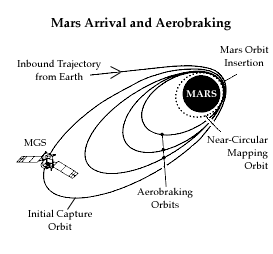 because the orbit is too highly elliptical. To obtain a more circular orbit, MGS could have carried more propellant for its rocket engine, and used thrust to shape its orbit. But that would have required a more powerful launch vehicle than the less expensive Delta-II, to loft a propellant-heavy spacecraft from Earth.
Instead, MGS will dip into Mars's upper atmosphere repeatedly, once each orbit, for four months. Each time it flies through the atmosphere, it slows down from the drag -- like you'd feel by holding your hand out the window of a car on a highway -- so it cannot climb quite so high away from Mars in the outbound portion of each orbit. Doing this requires some thruster firings for spacecraft control. This uses some propellant, but far less than would have been needed to circularize by rocket firings alone. These aerobraking maneuvers, remotely controlled by engineers hundreds of millions of kilometers away, will gradually reshape the spacecraft's orbit into a nearly circular path 380 to 440 kilometers above the surface, ideally suited for scanning Mars with scientific instruments.
because the orbit is too highly elliptical. To obtain a more circular orbit, MGS could have carried more propellant for its rocket engine, and used thrust to shape its orbit. But that would have required a more powerful launch vehicle than the less expensive Delta-II, to loft a propellant-heavy spacecraft from Earth.
Instead, MGS will dip into Mars's upper atmosphere repeatedly, once each orbit, for four months. Each time it flies through the atmosphere, it slows down from the drag -- like you'd feel by holding your hand out the window of a car on a highway -- so it cannot climb quite so high away from Mars in the outbound portion of each orbit. Doing this requires some thruster firings for spacecraft control. This uses some propellant, but far less than would have been needed to circularize by rocket firings alone. These aerobraking maneuvers, remotely controlled by engineers hundreds of millions of kilometers away, will gradually reshape the spacecraft's orbit into a nearly circular path 380 to 440 kilometers above the surface, ideally suited for scanning Mars with scientific instruments.
A Martian year of mapping
Once in its mapping orbit, MGS will complete each trip around Mars in about two hours. Each new orbit will bring the spacecraft over a different part of Mars, which is rotating below.
The spacecraft will adjust its attitude so that one side of the bus, called the nadir panel, always faces the Martian surface. Of the six science instruments, four - the
Mars Orbiter Camera (MOC), the
Mars Orbiter Laser Altimeter (MOLA), the
Electron Reflectometer (ER), and the
Thermal Emission Spectrometer (TES) - are attached to the nadir panel, along with the
Mars Relay (MR) radio system. The
magnetometer (MAG) sensors, mounted on the ends of the solar arrays, work together with the Electron Reflectometer to provide data on Martian magnetic fields.
As the weeks pass, the spacecraft will piece together a global portrait of Mars - capturing the planet's ancient cratered plains, huge canyon system, massive volcanoes, gigantic channels, and frozen polar caps. During its mission, MGS will pass over the terrain where the two (long inactive) U.S. Viking landers, separated by over 6,400 kilometers, have rested since 1976.
MGS's suite of onboard instruments will record detailed information from Mars. Detectors (described on the other side of this sheet) will measure radiation Ń visible and infrared Ń from the surface to determine the minerals that make up Mars. These same instruments will record radiation from the thin Martian atmosphere, gathering data about its changing pressure, composition, water content, and dust clouds. By firing short pulses of laser light at the surface and measuring the time the reflections take to return, a laser altimeter will map out the heights of Mars' mountains and the depths of its valleys. The camera system will use its wide-angle and narrow-angle components to record landforms and atmospheric cloud patterns. Another sensor will look for a Martian magnetic field. As the telecommunications subsystem transmits back to Earth, radio scientists and navigators will use the signal of the orbiting spacecraft to derive data about the planet's atmosphere and gravitational field. Communications with MGS, as well as navigational tracking, are carried out by NASA's Deep Space Network, which operates antenna complexes in California, Spain, and Australia.
Global mapping operations are scheduled to last one Mars year, just over two Earth years. After that, the spacecraft will remain in orbit, ready to relay communications from spacecraft from the U.S and other nations which might deploy Martian surface stations, rovers, or atmospheric vehicles.
MGS is but the first venture in the NASA NASA Mars Surveyor Program. Over the next decade, this program will launch Mars orbiters or landers every 25 months, using advanced technology to develop a comprehensive portrait of Mars. By studying Mars, scientists hope to better understand the formation and evolution of the inner solar system, including our home planet. This effort, which will involve international collaboration, is expected to help provide avenues for infusing science, mathematics, and engineering into our nation's educational system.
The Mars Surveyor Program and the Deep Space Network are managed for NASA by Caltech's Jet Propulsion Laboratory in Pasadena, California. Lockheed Martin Astronautics is NASA/JPL's industrial partner for the MGS spacecraft development and operations.
Further information
Don't miss the wealth of information which the MGS project updates frequently on the world-wide web by at http://mars.jpl.nasa.gov/mgs. Also, to keep up with discoveries from MGS, refer to publications such as Science News, Sky & Telescope, and Astronomy, which publish popular articles and images covering discoveries made by interplanetary missions such as MGS.
Your MGS kit could not have been produced without the kind permission of the National Aeronautics and Space Administration's Jet Propulsion Laboratory (Caltech), and the valuable technical reviews by the Mars Global Surveyor Project management and engineering. Copyright (c)1997 SCI Space Craft International, Pasadena, CA U.S.A. USA Note: JPL and NASA do not endorse this, or any commercial product.
| SCI HOME PAGE
| CATALOG
| HOW TO ORDER
| GREAT SPACE LINKS |